Urban Planning and Development in João Paulo, Florianópolis
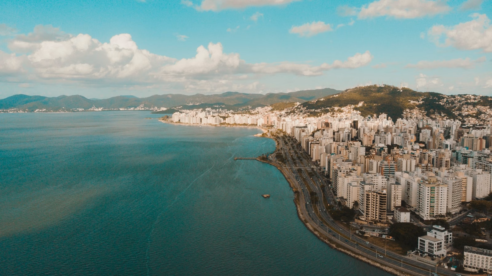
João Paulo has well-defined urban morphology: flat, low-altitude area close to SC-401 with medium- to high-end residential buildings; hillsides with preservation restrictions; and the Northern Bay waterfront inaccessible for construction—permanently guaranteeing unobstructed bay views for properties.
Understanding how this neighborhood is structured—its legal boundaries, zoning, history and ongoing construction—is essential for anyone buying property here or analyzing appreciation potential.
Origin and official recognition
João Paulo was originally part of Saco Grande, then known as Saco Grande I. With the implementation of SC-401 in the 1970s, the highway became the physical divider between neighborhoods. Official recognition as an autonomous neighborhood came through Municipal Complementary Law No. 001/1997, which established João Paulo’s official boundaries as an administrative district of Florianópolis.
Basic data: – Total area: 3.2 km² – Central coordinates: −27.557705, −48.506398 – Reference postal code: 88030-300 – Location: western coast of Santa Catarina Island, between Downtown and North Island
Boundaries and neighboring neighborhoods
| Direction | Neighborhood / Landmark |
|---|---|
| South | Itacorubi |
| North | Cacupé |
| East | Saco Grande |
| West | Northern Bay (ocean) |
SC-401 borders the neighborhood along the western coast, functioning as the primary access route and mobility corridor between Downtown and North Island. Alternative access to the neighborhood is via Beira-Mar Norte Avenue, which connects to SC-401 further south.
João Paulo zoning
João Paulo zoning follows the Florianópolis Master Plan—Municipal Complementary Law No. 482/2014, administered by the municipal government (PMF). The relevant zones within the neighborhood are:
ARP—Predominantly Residential Area
Predominates in hillsides and neighborhood interior. Permits residential buildings and uses compatible with the neighborhood character. This is the zone concentrating gated communities of houses and part of medium-standard residential buildings.
APL-E—Limited Use Preservation Area (Hillsides)
Corresponds to steeper hillsides and ridgelines, including the João Paulo Hill area. APL-E severely restricts construction—in many cases, prohibits it entirely. Anyone seeking hillside land for building in João Paulo must verify exact zoning classification before any negotiation.
AMS / ARM—Mixed Use
Commercial strips along the main highway (SC-401). Permits commerce, services and mixed residential-commercial use. This is where Angeloni supermarket, Primavera Office and larger commercial establishments are located.
APP—Permanent Preservation Area
Ponta do Goulart is a Protected Area (APP) within the neighborhood. Access for recreation is permitted, but construction is prohibited. This ensures preservation of beaches and vegetation at the point—and consequently maintains views for nearby properties without risk of new construction blocking the landscape.
How to consult exact zoning
The PMF GeoPortal (geoportal.pmf.sc.gov.br) permits consultation by address or coordinates. For any purchase, construction or regularization decision in João Paulo, GeoPortal consultation is mandatory. Zoning varies by block and may have zone overlaps.
SC-401 tripling: the largest urban infrastructure project in the area
The SC-401 tripling is the most relevant highway infrastructure work for João Paulo in the coming years. The numbers:
| Item | Data |
|---|---|
| Investment | R$ 73 million |
| Extent | ~10 km |
| Status (Apr/2026) | 60% complete |
| Projected completion | September 2026 |
| Travel time reduction | Up to 40% |
| Program | Estrada Boa (SC State Government) |
The project consists of expanding the highway from two to three lanes per direction in the section bordering João Paulo, eliminating the historic bottleneck that makes travel across North Island problematic during peak hours.
What changes for João Paulo specifically
The neighborhood sits in the section directly benefiting from the work. Anyone working Downtown and living in João Paulo—or vice versa—will feel the difference immediately. Improved highway accessibility directly impacts property values: well-serviced neighborhoods appreciate faster and maintain higher liquidity.
For buyers in 2026, you are buying before project completion. Current pricing already accounts for part of the future benefit, but post-completion appreciation is expected.
ParqTec ACATE and Passeio Sapiens: tech hub inside the neighborhood
The ParqTec ACATE has operated in João Paulo since 2009. It is the technology park of the Catarinense Association of Technology (ACATE), with software companies, startups and innovation centers located within the neighborhood.
In June 2024, Passeio Sapiens opened—an innovation center with dining spaces, corporate events, shows and coworking. Passeio Sapiens already logs 30,000 visitors per month.
The urban impact is clear: the tech hub qualifies the surrounding area, attracts high-income workforce and generates demand for high-end housing near workplaces. This sustains both rental and sales market in João Paulo.
Urban morphology: how the neighborhood is physically organized
João Paulo has two distinct construction patterns:
1. Flat area (near SC-401): residential buildings 4 to 12 stories, medium to high-end standard, typically with complete recreation areas. This is where the most significant launches of recent years are located.
2. Hillsides: gated house communities (rapid growth post-2010), single-family residences, trails and preservation areas. Occupation is less dense, lots are larger and APL-E restriction applies partially.
The Northern Bay waterfront is not developable—the Protected Area (APP) strip and SC-401 itself prevent construction between the neighborhood and the ocean. This permanently guarantees bay views for buildings with western exposure.
Planned urban development projects
Beyond SC-401 tripling, other relevant developments:
- Passeio Sapiens expansion: the ACATE tech hub has expansion plans that should increase visitor and worker flow to the neighborhood.
- New residential projects: Villa Maggiore (Fontana Construtora) launched in Q1 2026. Reserva João Paulo is in pre-launch. The trend of new projects continues given the neighborhood still has usable area in the flat zone.
- Bicycle lane expansion: the PMF +Pedal Program foresees continuous expansion of the bike path network, already connecting João Paulo to Santo Antônio de Lisboa, Saco Grande and Cacupé.
Building restrictions relevant for anyone wanting to construct
Anyone with land or thinking of buying land in João Paulo to build must verify:
- Zone classification: ARP permits construction with limited height; APL-E may prohibit entirely.
- Slope: hillsides above a certain percentage have automatic restrictions under the Master Plan.
- APP: any land near Ponta do Goulart or watercourses must respect the Protected Area (APP) buffer.
- Mandatory consultation: PMF GeoPortal (geoportal.pmf.sc.gov.br) and SMDU (Municipal Department of Urban Development).
Summary: João Paulo from the urban planning perspective
The neighborhood is at a moment of positive convergence: highway work nearing completion, tech hub expanding, new residential launches, and zoning that preserves natural advantages (views, Protected Areas, hillsides). For anyone analyzing property in João Paulo from an urban planning standpoint, the scenario over the next 12–24 months is improved accessibility while maintaining the residential character that makes the neighborhood valuable.
Sources: Municipal Complementary Law No. 001/1997; Florianópolis Master Plan—LC No. 482/2014; NDMais and AgoraFloripa (SC-401 tripling, Apr/2026); ACATE (Passeio Sapiens); PMF GeoPortal.